<
The Tsugaru region, which was ruled by Mr. Nambu during the Warring States period, was recognized as Hideyoshi by Odawara's early arrival team of Oura (Tsugaru) Teishin (Ourare Nobu), and was no longer a territory of Mr. Nami. As a result, Ijo Sanko (Mino's To, Aomori Pref. Sannocho) will be concentrated to the north of the territory, and will be at a geographically inappropriate position as a government office. So the southern part of the Nobuna, after Kunoge Masami's revolt, changed its home castle, Kuto Castle (Ninohe city), renamed Fukuoka Castle. In addition, there is a recommendation of Gyu-Ushi-Sato (Gaugo Ujisato) and Asano Nagamasa (A-Na-Na-Gasa), and it is decided to let the castle go southward to Iwao-gun Hitoh (Nishou-go). To do. It is the birth of the new city "Morioka".
The reason why Morioka was chosen is (1) that it was a key point of transportation that water transportation of the Kitakami River can use, (2) Shibutan (Sibutabami, Morioka city) of the north and Numamiyai (not stupid, Iwate town) These include the fact that it was along the highway that reaches Kuchinohe Castle via, etc., and (3) that it was a natural disaster that consisted of the granite (kaganan) plateau surrounded by the Kitakami River and the Nakatsu River.
Nobunao received permission from Hideyoshi in the year of Bungomoto (1592) and started land preparation work. Although there are various theories for the start of the castle construction, the Keicho 3 (1598) year theory seems to be appropriate. The actual command of the construction was hit by Nobunaga's Keiko Toshinao, often interrupted by Hideyoshi in Keisen 3 (1598) and the death of Shinonori in the next Keicho 4 (1599). The middle of the year (1596 to 1615) seems to have completed once in a while. After that, however, it was frequently damaged by floods, and it was officially designated as a castle when Kanei 10 (1633) returned to Japan after the third generation lord Shinoshi. It actually took 36 years.
Around the time of the castle construction, the town planning also began. The town under the castle had a policy of making it a "five-letter" street. More than 500 stone senior warriors in the first zone centered on the castle, merchants and craftsmen in the second zone, general warriors less than 500 stones in the third zone, footlights along the highway from the castle to the villages (concentric ) Was put. Ueda-gumi-cho and Senboku-gumi-cho are here. Furthermore, from the point of view of defense, relocation and construction of shrines and temples were carried out at the foot of the castle northeast.
In Kashiwa-cho, Shimokoji (near Shikoji and Ehime-cho) and Kamishu (Kamishu) Koji (near Baba-cho) are first made, and then, after the renovation work on Kitakami River, Osawa Kawahara (Oosawa Kawawara / Osawagawara) In the vicinity of 3-chome), Hashiko-koji (hirayama) and Hirayama-koji (near Chuo-dori 3-chome) were born.
The townspeople are born with the name of the merchant's birthplace. With the beginning of "Mino-cho (nsancho · Honcho 3-chome)", a townman who came from Sanyo, "Senhoku-cho (near Senhoku 1-chome)" of a towner who came from Senboku-gun, Akita Prefecture, etc. , "Morioka twenty-three town" was established in the year of Keian 4 (1651).
Morioka twenty three town
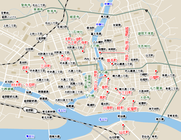
Senbokucho (senbokucho) → Senboku 1-chome
The town named Senboku-cho has been described as a town created by the people who moved from Senboku-gun, Akita Prefecture, and lived on the west bank of the Kitakami River during the era of the second generation lord, Toshinao. As it is the key point of Morioka's transportation and the large grain area of Shiwa county, it was a prosperous town with large rice commerce and liquor stores.
Ashiya Town (Tatayaya) → Ashiya Town
The name of the town is that once a long-time business man-in-the-field chief Kiyoshi came to Morioka from Kyoto and built a temple called Yakuzayama Bodenin (Yaokusanbo Iin). In the old town of Ashiya-cho, there were a water town (Kako-cho), a cross, Shita-cho, and a shrine. The water owner (Kako) was working on the water transportation boat of the Kitakami River and the Kashiwa Bridge. In addition, I was also responsible for taking small fish to be eaten by the crane I have kept.
Ashiya town is the first road to get into Morioka for people who come from Miyako, Kamaishi, Oyama, and so on, so there are lots of small and large shops that can do various shopping here was there. Daiji Shimizu and Seiryusui are famous, but this spring is warm enough to be steamy in winter, so bring vegetables from the area of Kikoda (Mikoda) and Senbokucho and wash, and then pick up the blue fish from Macho. Many people went to the market.
Kawahara-cho (Kawacho-cho) / grain town (Koku-cho) → Minami Odori 2-chome
Cereal town is a town centered on Xiamen, along with a new cereal town created later. Culture 9 (1812), divided into two towns. There were many good sellers in both towns and Kawahara-cho, and it was the most thriving area in Morioka Shiroshita, along with various trading houses including Itoji, Kizuya and Izumiya.
The town was originally called Mikkamachi, but it was called the town because it was dumped with rice from the Miyama of the Shinzankaigan on the 9th, 19th, and 29th of the race. In Xiamen, there are 24 houses of prototypes, a go-ban, and an officer's residence, which investigates the entrance of goods and people to the castle. The gate opened at 6 am and closed at 6 pm. In addition, there are many inn in grain town, and merchants from countries and shonais, travelers, and dispatch groups of northeast lords of the north guard have stayed.
13-day Nichimachi (Mr. 10) → Kojimachi
In 13-day town, there was a large bell to tell the time at Horibata. In addition, there was a lumber shop in Tokaichi-cho because it carried timber from the shore of the moat of Toku-roku (Toruka). The reason that there were many inn shops was because they were close to Xiamen, Meiji Bridge and Umamachi, and travelers came in and out, but there were a lot of shops and there was an open space in the back of the house using the water of Nakatsugawa. It is said.
Mamachi (Umamachi) → Shimizu-cho
In Morioka 7 (1710), the place to buy and sell horses was decided for the first time in Morioka. That's the beginning of Ma-cho, where it lasted until recently. It came from the Shimokita (Aomori) region during the Morioka Zen period, and all horse buying and selling in Shonai were crowded in this horse town and it was so crowded. In 1890, when a production horse association was established, a horse testing station was created in Ma-cho, and there are many large houses in Ma-cho, and it is possible to have 80 horses in one house alone. It was said that I could stay at home. In 1912, the horse station in Macho moved to Shinmacho (now Matsuocho).
Hachimancho (Hachimancho) → Hachimancho
Morioka Castle was built, and a shrine was built here, and it was at the center of the stability and faith of the people's mind. Morioka Hachimangu Shrine was completed in Enoki 8 (1680). Hachimancho was born as a new town. It is a time of the four generation lord, Shigenobu. As they allowed the common people to worship, the common people gathered from the castle and nearby neighborhoods, became a great festival, and the "Yabusame" was also held, continuing today.
The city day of Yawata-cho in Yinbao 8 (1680) is considered to be 1, 3, 6, 8, 11, 11, 13, 16 days, and it was prohibited to set up a city in other towns. Therefore, Hachiman-cho Kaiwai prospered with the years, and became a entertainment district as a typical Monzen-cho.
Kurate-cho (Fukudecho ・ original roof ・ town ・ Yanefukicho) → Nakanohashi street 1-chome
Kabute-cho lived in the north 1-chome of Kashi-cho, with many roof tiles. The side road from Ashiya-cho to Karate-cho was called Aizen Yokocho. It was in the first year of the Qin Qian (1741) to allow the rubble to come. The decree says, "This is acceptable for the sake of caution under fire. It is acceptable for Sakai yashiki, Teramachi, and any town." Because the fire was horrible, the rubble might have been safer than straw and straw, but in the old days there were many fires.
The number of houses in Karate-cho is 38 according to a survey of Tenmei 8 (1788), and the number of residents is 327. In the same survey, there are 226 carpenter towns (Daikou) with 715 people, so there are more residents per household in Karate town. It would be a row of small houses with long houses.
Sakamachi (Sakana chow) → Kojimachi
Kashiwacho, one of the shopping districts that still represents Morioka, prospered during the Shosei period, with its position and conditions like the corner of the fan of Morioka Shiroshita and Henan. A boat from Edo carries "downfall" to the river port Kawahara-cho, Shinzan riverbank of Kitakami River, and from the Japan Sea, it is landed at Nohechi Port (Ryo Port in Aomori Bay, Morioka Ryori). Products also included. The common sense that such "good items are in Kojimachi" remained until the Meiji and Taisho eras.
Shin-machi (later in Kimono-cho, Gofuku-machi), Rokkamachi (Mukai-cho) → Nakanohashi street 1-chome
It was originally Shin-machi, and it was renamed Kaifuku-cho in the 9th year of culture (1812), and it was also called Nakamachi. "Morioka Sanko (Sunako)" says "Seifukucho is" the bill of the bill "" Minami Nicho ", but" the bill of the bill "is the Iwate Bank Nakanohashi branch, and the 26th is the city day of Shinmachi every month The According to the number of "Nanbu Gojokin Susetsu Larujin" numbered in Keio 4 (1868), Nishikata Ozeki, Izutsuya Zenhakuro who was the largest branch of the Ono group Headed by Shibuya Yoshibei (miso sauce, miso soup), Omiya Yurobei (mofu jacket), Izutsuya Tokujuro (sake shop), Omiya yakan Saemon (Sake shop), Omiya yasuroku (pawn shop), Omiya ya Koube (呉 shop) Long-established store such as) had a store.
Rokkamachi is located between Sugamo-cho and Sojo-koji. The city day is every month on the 6th and 16th, and there are shops such as Kotsuya Gonji (Soy Sauce) and Aiya Yason Six (Ayuya). The predecessor of Morioka Chuo Post Office Morioka Post Office was established in May 1887 in this 6 day town.
Ashiya-cho (Konya-cho), Blacksmith-cho (kaji-cho), Paper-cho (Kamicho) → Ashiya-cho
During the Qing Edo period, the upper, middle and lower Nakatsugawa Mihashi bridges the lower part of Morioka Castle, and between the upper bridge and the inner bridge, from the upstream along the Nakatsugawa east bank, a succession of paper towns, black towns and Ashiya towns. A large townscape was created. In this town, Kakuya Shigeya in Ashiyacho, Sawaiya Kyubei (Gozaku), Izutsuya Denbei, and Mukaiya Hanbei in Blacksmith Town, Kachiya Seika, or Izutsuya Ryobei in Paper Town at the end of the Bakumatsu Period, One of the most prestigious businessmen of Otsukaya Sobei, has become the main shopping street in Morioka Castle. The storefront of Suzuri-ku in Ashiya-cho still has the old appearance of the old Morioka.
In addition, the road here was a key route of Oshu Dochu (highway) during the Shosei period. At that time, during the Oshu Dou, I entered the somon of the grain town, passed through here, and passed from the Honcho to the direction of Ueda through the upper bridge. Therefore, there was a signpost in the middle of Black Town, and it was the starting point that measured the distance to Shonai.
Honcho (ほ ん), oil town (大 工 町), carpenter town (ち ょ う ・), Teramachi (Teramachi) → Honcho street 1-chome
Motomachi is part of the Oshu road that runs east and west in the leading edge of Morioka Castle, and many merchants who came down from the Kyoto area lived there, so I first call it Kyomachi (Kyomachi), but the cultural year (1804 It became ~ 18) and was changed to Honmachi. By the end of the Bakumatsu period, shops such as Hinoya Ichibei, Yamatoya Shigeoemon, Takadaya Isuke, Iwaiya Konsuke, and Kagiya Ibei were the main shopping streets in the Hebei area.
In addition, the town line west of Honcho is Yokamachi, and there was an oil town and a carpenter town in the back of the main town. There were oil shops, rough shops and beef horses in the oil town, and a lot of carpenters had lived there, and there was a carpenter's head. And the route from Honmachi to the Kitayama temple area has long been called Teramachi, but it was changed to Hanayacho after the cultural year.
Yokamachi (Yokokacho) → Honcho Dori 2-chome
Yokakamachi is next to the west of Kyomachi, which was renamed Honmachi in 1812, and Honcho is the 28th of every month, and this town is the 8th of the city. According to the city day of Honcho, compared to the city day of other towns, it is said that there were a lot of commerce of the miscellaneous goods above. In addition, there is Yotsuyamachi to the north of Hatsukamachi, and there was an exit to Ueda, Yotsuya Gate before the Akagawa Bridge. In the vicinity, there is a buccho in the north, and there is a humble house called Tani Koji.
Sancho-cho (san's hou) → Honcho street 3-chome
It was the first time in the castle that it was named Sannobe in the era of the second generation lord, Toshinao, in the era of the 2nd generation lord (1617), who moved the people of the southern family ancestral Sanbejo castle to the new ground of Morioka. It was one of the townspeople.
It was also said that it was "Tamachi" because it was moved to a town built in a paddy field area, though it was an area of the Daiyotsu family (outside the Hijikadomon) and Sancho-cho. It is the first time here that the city day of the 11th and 21st of the month has been set, and it has been done from dealings such as rice grain to buying horses etc. It seems to have shown a very prosperity. There is a record that a bell tower was built in Sanbecho in 1680. The bell is Goro Koizumi, a seven-year-old man who casts a pot on the roof of the Morioka Castle castle tower the same year.
Nagamachi (Nagamachi, later Nagai Town, Nagachosho) → Nagatacho
Nagamachi is the name of the longest town in the castle town, but it has also been called "Choi" during the cultural year. Twenty-seven young people from Nagamachi wished to serve firefighting in 1799, and they were told that the town's firefighting team in Morioka had risen to this. In addition, in the middle of the east side of Nagamachi, there was a prison house called "Agariya" to hold undecided criminals during the Shosei period.
Timber Town (Zaimokucho, original Kate Town, Iwatesho), Kuji Town (later for Tsubaki Town, Kayako) → Timber Town
Timber town is once known as Kanote town. It was changed to lumber town in 1655, and after that it was called mochi town, but it was determined to be lumber town in the cultural year (1804 to 18). In addition, the northern part of the town that continues to lumber town is once called Kuji town, but this was also changed to town in 1812.
From lumber town to lumber town during the Edo period, Takizawa prospered as a shopping district with the direction of Takizawa, Kamogawa and Shizukuishi. By the end of the Edo period, there were large shops such as Omiya ya Kanbei, Ebisu yasuke 衛 emon, Miyataya Shigeharu, Toshiya Kinosuke etc. It was lined up.
The Yufa Se Bridge, which leads to Nitta Town from here, was washed away every flood, so in 1765, Nakajima was built with a large stone in the Kitakami River, and the bridge girder was raised and bridged. So, I was told that there was no bridge comparable to this north of Kanto. At the foot of the bridge on the side of the town, there were a gate to the face of the sea and a gobansho.
Iwate's Cultural Information Encyclopedia (Iwate's Castle / Hall: Morioka Castle )