| Specified type | Country designation |
|---|---|
| Type | Historic site |
| Designated date | January 31, 2000 |
| Specified details | |
| quantity | |
| location | Kitakami City, Kanegasaki Town |
| owner | Outside Kitakami city |
| Holding group | |
| Management organization | |
| home page |
Overview
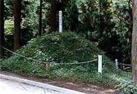
In 1964 (1642), following the decision of the Tokugawa Shogunate, the boundaries of the southern territories and the Dates were decided, and from the summit of the Ouzan mountain range to Mt. The Sakaizuka was built on a border that extends approximately 130 km.
There are Otsuka and Otsuka (Kozuka), and after Otsuka was built in 1969, it seems that Otsuka was built between Otsukas by Genroku (1688-).
In addition, in particularly important areas, there are also built up opposing mounds (scissors).
The Sakaizuka itself is found in many places, but it is a large-scale border facility that is unmatched in the whole country, and a valuable monument that shows the political tension of the Tohoku region from the Tokugawa Shogunate era.
The designated area is about 11 km in Kitakami city and Kanegasaki town, and in the meantime, it is an area where it counts Otsuka 17, Sakaizuka 2, and Kozuka 198 or so.