| Pseudonym reading | Check the schedule |
|---|---|
| Specified type | Prefecture designation |
| Type | Historic site |
| Designated date | July 19, 1957 |
| Specified details | |
| quantity | |
| location | Iwate Town Oji Kubo |
| owner | Individual |
| Holding group | |
| Management organization | |
| home page |
Overview
It is located about 3 km west of the JR Tohoku Line Numamiyauchi Station, on the east end of a low hill which is connected to the south side of the flat surface of the well.
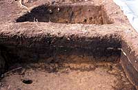
The ruins of the residence are currently hollow and there are 40 places where you can find out whereabouts.
The pit has a floor surface about 1 m below the ground surface, and the planar shape is a rounded square with one side of about 6 to 8 m.
There is a weir on the west central wall, and a flue of about 1.5m is made.
As for the relics, pottery such as pottery, pottery and pottery, spindles, etc. are excavated.
The pottery was made without using Rokuro, and the Sue instrument was not accompanied.
When the pit dwellings were destroyed and several decades passed, there was a large volcanic eruption, and a layer of deposited ash in the pit was found in each pit.
The period is estimated to be the Nara period or a time when it slightly climbs up, and it is a valuable monument to know the culture of this period in the prefecture.